


TouchTrails
Route Planner

คำอธิบายของTouchTrails: Route Planner
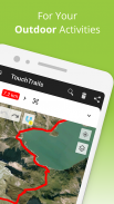
TouchTrails เป็นเครื่องมือวางแผนเส้นทางที่ใช้งานง่ายสำหรับการผจญภัยกลางแจ้งทั้งหมดของคุณ เพียงติดตามเส้นทางของคุณบนแผนที่ด้วยนิ้วของคุณเพื่อรับข้อมูลระยะทางที่แม่นยำและโปรไฟล์ระดับความสูงโดยละเอียด
วางแผนเส้นทางสำหรับการขี่จักรยานครั้งต่อไปหรือการผจญภัยเดินป่าหลายวัน จากนั้นตามด้วยการนำทางด้วยเสียงแบบเลี้ยวต่อเลี้ยว
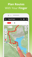
วางแผนและปรับแต่งเส้นทางของคุณ
วาดเส้นทางได้ทุกที่ด้วยนิ้วของคุณ Snap to road ช่วยให้คุณอยู่ในเส้นทาง แต่คุณยังสามารถขับขี่แบบออฟโรดได้อย่างสมบูรณ์อีกด้วย TouchTrails ให้ความยืดหยุ่นในการสร้างเส้นทางที่เหมาะกับความต้องการของคุณ แยกเส้นทาง ลบส่วนต่างๆ หรือเชื่อมต่อ
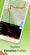
วัดระยะทางและระดับความสูง
การวัดระยะทางที่แม่นยำและโปรไฟล์ระดับความสูงโดยละเอียดช่วยให้คุณเข้าใจว่าการผจญภัยของคุณจะพาคุณไปไกลแค่ไหนและสูงแค่ไหน
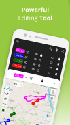
เพิ่มและแก้ไขเวย์พอยท์
ปรับปรุงแผนที่ของคุณด้วยไฮไลท์ เคล็ดลับ และจุดสนใจด้วยเวย์พอยท์ คลังไอคอนเวย์พอยท์มากมายช่วยให้คุณปรับแต่งแผนที่ของคุณได้
ตัวติดตาม GPS
บันทึกการผจญภัยของคุณด้วยตัวติดตาม GPS บันทึก แก้ไข หรือแชร์การเดินทางของคุณกับเพื่อน ๆ
โปรแกรมดู GPX
พบเส้นทางที่สมบูรณ์แบบบนเว็บหรือไม่? นำเข้าไฟล์ GPX ได้จากทุกที่ นำทางไปตามเส้นทาง วัดระยะทาง และวิเคราะห์โปรไฟล์ระดับความสูง แก้ไขตามที่คุณต้องการ
หลายเส้นทางบนแผนที่เดียว
คุณไม่ได้จำกัดอยู่เพียงเส้นทางเดียวบนแผนที่ TouchTrails ช่วยให้คุณดูหลายเส้นทางพร้อมกันบนแผนที่เดียว ความยืดหยุ่นของ TouchTrails ยังช่วยให้คุณสามารถรวมและเชื่อมต่อเส้นทางจากแหล่งต่างๆ ได้
แชร์เส้นทาง
ส่งเส้นทางของคุณให้เพื่อน ๆ และแบ่งปันการผจญภัยของคุณกับพวกเขา
TouchTrails เป็นแอปการวางแผนเส้นทาง การติดตาม GPS และ การนำทาง ที่สมบูรณ์แบบสำหรับการผจญภัยกลางแจ้งทุกประเภท รวมถึง:
• วิ่ง เดิน และเดินป่า
• ปั่นจักรยานและปั่นจักรยานเสือภูเขา
• ขี่มอเตอร์ไซค์
• การโอเวอร์แลนด์
• เล่นสกี
• แมนเทรลลิง
• และอื่น ๆ อีกมากมาย!
TouchTrails พรีเมียม
อัปเกรดเป็น TouchTrails Premium เพื่อพลังพิเศษที่มากยิ่งขึ้น!
• จัดชิดถนน
o TouchTrails จะล็อคเข้ากับถนน เส้นทางจักรยาน หรือเส้นทางเดินป่าทันที
• การนำทางแบบเลี้ยวต่อเลี้ยว
◦ เตือนคุณเมื่อคุณออกจากเส้นทาง
◦ คำแนะนำแบบเลี้ยวต่อเลี้ยวผ่านเสียง
• เข้าถึงสัญลักษณ์มากกว่า 100 รายการเพื่อปรับแต่งเวย์พอยท์
• บันทึกเส้นทางได้ไม่จำกัดจำนวน
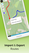
• ส่งออกไฟล์ GPX
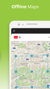
• แผนที่ออฟไลน์เพื่อใช้ TouchTrails แม้ว่าอินเทอร์เน็ตจะไม่พร้อมใช้งานหรือไม่น่าเชื่อถือก็ตาม
สำหรับการสนับสนุนและเคล็ดลับ โปรดไปที่
https://www.touchtrails.com/docs/user-guide
ติดตั้ง TouchTrails ทันทีและปูทางสู่การผจญภัยที่น่าจดจำ! 🌲🚴🏃
TouchTrails: Route Planner--เวอร์ชั่น2.14.0
(09-07-2025)
TouchTrails: Route Planner - ข้อมูล APK
เวอร์ชั่น APK: 2.14.0แพ็คเกจ: com.wolfgangknecht.sketchatrackเวอร์ชั่นล่าสุดของTouchTrails: Route Planner
เวอร์ชั่นอื่น


แอปในประเภทเดียวกัน


